Station Selected:

Second winter storm to impact Wisconsin this week
The winter storm is expected to impact travel all across the state on Friday.
By Jimmie KaskaShare
MADISON, Wis. (Civic Media) – A second winter storm system is expected to bring several inches of snow across Wisconsin this week.
After a winter storm hit mostly southwestern and south-central Wisconsin earlier in the week, dumping up to a foot of snow in some places, a second storm could replicate those snow totals across a larger part of the state.
Winter storm watches and warnings are being issued ahead of the snowfall, which is expected to begin overnight Thursday into Friday and last until Saturday morning.
In addition to the state’s 511 service, which shows winter road conditions for Wisconsin’s main highways and real-time traffic cameras and traffic alerts, ReadyWisconsin is offering some safety tips ahead of the winter storm:
- Make sure you have fully stocked emergency kits in your home and your vehicle. Home kits should include items like non-perishable food, fresh water, and a first aid kit. Vehicle kits should also have extra hats and gloves, blankets, an ice scraper, snow shovel, and kitty litter or sand to give you traction in case you get stuck in the snow. Find tips on what to include in your kit at https://readywisconsin.wi.gov/make-a-kit/.
- To help protect yourself in your vehicle, remain distraction-free while driving and adjust your speed for current conditions.
- If you get stuck while traveling, remain with your vehicle if it’s safe to do so and contact 9-1-1. Give police a description of your location and wait for help to arrive.
- Be prepared for power outages. Plan for batteries and other alternatives to meet your needs. Keep mobile devices fully charged and keep gas tanks full. Talk to your medical provider about a power outage plan for essential health care devices that are powered by electricity and refrigerated medications. You can monitor power outages at PowerOutage.us.
- Bring your pets indoors. If you cannot bring them inside, provide adequate shelter to keep them warm and make sure they have access to unfrozen water.
- After the snow ends, give road crews room to work. In addition to clearing snow from driveways and walkways, check external vents on your home for blockages. If you have a fire hydrant on your property, clear the snow so there’s at least three feet of open space around it.
As of Thursday afternoon, the National Weather Service was predicting snowfall of 10 to 18 inches across southern Wisconsin, except near Lake Michigan, where warm lake waters will keep the precipitation from being all snow. The line for the heaviest snowfall was roughly southeast from La Crosse to the Fox Valley, with cities like Madison, Fond du Lac, Wisconsin Dells, Oshkosh and Richland Center in the center of the heaviest expected snowfall.
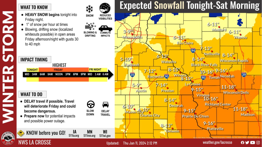
Northern parts of Wisconsin will see around a half foot of snow or more after largely missing out on the storm earlier this week. Far southeastern Wisconsin, which is under a Winter Storm Watch, may see similarly lighter snowfalls. Forecasters Thursday said that there is uncertainty with what precipitation type areas like Milwaukee, Kenosha and Racine will get due to warmer temperatures along Lake Michigan, with a chance of rain or mixed precipitation reducing snowfall totals.
In addition to heavy snow, which might fall at a rate of one to two inches per hour, winds will gust up to 40 miles per hour, which could lead to blowing and drifting, especially in areas where there’s nothing to block the wind near roadways. After the snow is done, temperatures will fall into the single digits, with wind chills below zero this weekend. The National Weather Service says they do not expect the storm to be upgraded to a blizzard warning because winds won’t be strong enough to push it to that category.
“[The storm] will bring strong winds – sustained winds of 20 to 30mph and gusts of 35 to 50mph – Friday afternoon and night,” the National Weather Service said in its forecast discussion. “The winds are not quite as strong in our area, so we did not go with any blizzard warning. However, we could still see some brief white-outs.”
The impending winter storm has also prompted school closures for most of southern Wisconsin on Friday.
The Wisconsin Department of Transportation is advising that anyone that has to travel follow some of these safety tips:
Preparation before winter travel
- Monitor local forecasts as winter weather events can develop and change rapidly.
- Check 511wi.gov for road conditions or incidents along your route. Download the 511 Wisconsin app to monitor conditions on the go. Follow 511 Wisconsin (@511WI) for the latest incidents and information.
- Clear snow and ice from vehicles before traveling.
- Fill the gas tank and windshield washer fluid.
- Have a fully charged phone and an emergency kit in your vehicle.
- Alert others about your route and expected travel time.
Precautions while driving
- Snow means slow. Allow extra travel time, following distance, and reduce your speed during winter conditions.
- Be cautious on bridges, overpasses, and entrance and exit ramps.
- Don’t be overconfident in four-wheel or all-wheel-drive vehicles. All vehicles require additional time and distance to stop in adverse conditions.
- Avoid using cruise control in winter conditions.
- Buckle up and put your phone down while driving. Every trip, every time.
- Leave room for maintenance vehicles and snowplows. Move over or slow down for stopped emergency vehicles.
- Stay at least 200 feet behind a working snowplow. Make sure that you can see the plow’s mirrors to ensure the driver can see you.
- In case of a crash or slide off, stay in the vehicle, turn on the hazards, call 911 and move vehicle(s) out of traffic if possible.