
We just experienced the warmest winter ever on record, now what?
Mar 1, 2024, 11:23 AM CT
Share
MILWAUKEE, Wis. (CIVIC MEDIA) – Meteorologist’s close the books on winter marking a major temperature rise that shatters seasonal records.
With February in the rearview mirror, it marks the end of ‘Meteorological Winter’. Winter for scientists is divided into 3 month sections for seasons. So December, January and February is winter. It’s been a wildly warm one and now we can officially say that it’s in the record books.
Milwaukee felt an average overall temperature of 34.6 degrees over the past three months. This is two degrees warmer than the three-month average across the city’s prior warmest-ever winter, which was in 1931/1932 with an average temp of 32.6 degrees.
Wausau averaged 28.6 degrees for December, January, and February. This shatters the previous record of 26.9 degrees, which was set back in the winter of 1997/1998, which was also a strong El Niño winter.
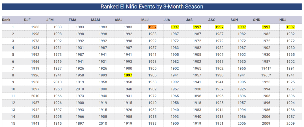
The story is similar in the Northwoods, too. Rhinelander’s average temperature for the entire meteorological winter will go into the books as 25.5 degrees. Destroying the previous record of 24.5 degrees, which was also set back in the winter of 1997/1998.
From the state’s warmest Christmas on record to Wisconsin’s first and only February tornado and then this week’s historic 50-degree temperature swing, this winter has been one to remember.
December of 2023 and February of 2024 both are set in history now as the warmest overall we ever experienced for those months. January of 2024 was Wisconsin’s 10th-warmest on record, despite the only cold snap we had.
This year’s warm winter was courtesy of El Niño, and Wisconsinites knew to expect a milder one than usual. But climate change means that snow-dependent recreational activities face a frightening future as the state experiences new extremes.
Parts of Wisconsin are some of the most susceptible to the near-term impacts of climate change, says the Wisconsin Initiative on Climate Change Impacts Tourism and Outdoor Recreation Working Group.
Climate forecast models show that during the winter months, more precipitation will fall as rain rather than snow. And as warmer weather begins to last longer, the window for outdoor winter recreation will narrow.
As we look ahead to March, the trend continues. NOAA’s outlook keeps us warm, still predicting highs continue to stay above normal.
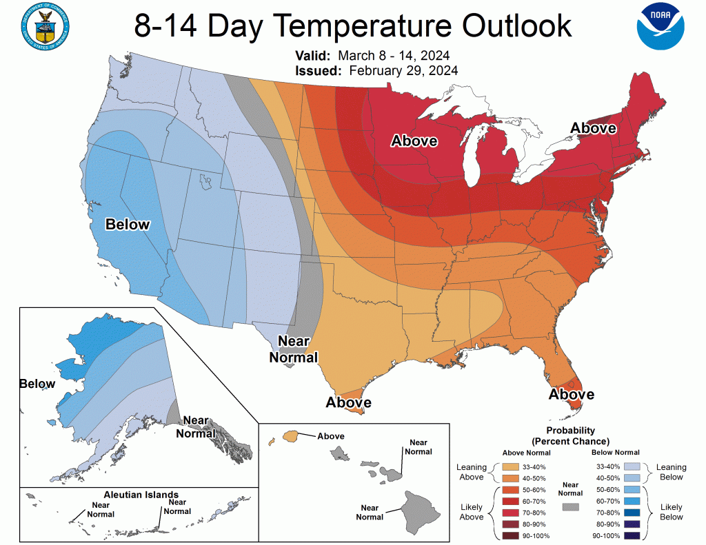
Average highs through the state of Wisconsin for the beginning half of March typically range from the low 30s in the Northwoods, rising to the mid 30s. While south near the cities, highs hit the upper 30s to start the month and wind up in the low 40s by mid-month. NOAA says, expect them to be warmer.
With the winds whipping and warmth returning this weekend, a high fire risk will spread throughout the state. Dry and dead vegetation will act as fuel for fires and the winds spread it quickly. Keep in mind that until the grass greens up, this is prime time for wildfires.
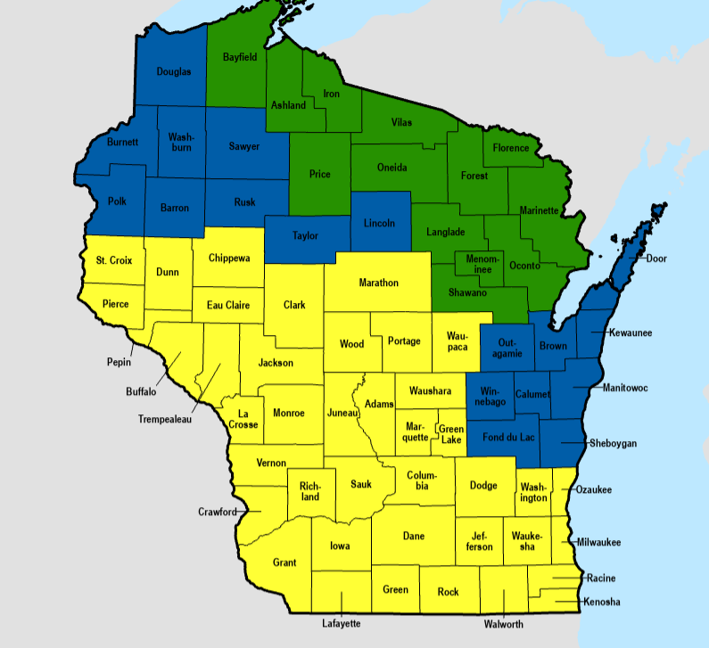
YELLOW: High Fire Danger. BLUE: Moderate. GREEN: Good.
With the lack of snow this winter and the rain not rolling in until Sunday night, drought conditions have also crept up in the state.
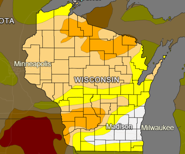
65% of Wisconsin is now in a drought. With 17% of the state tapping severe levels.
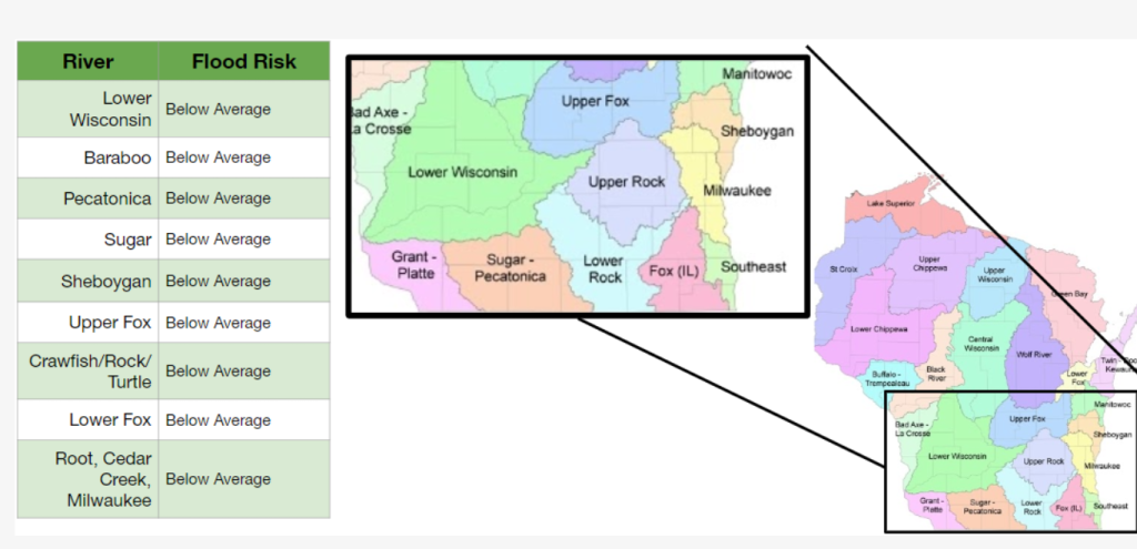
Spring is typically when the snow rapidly melts, with arriving rain that creates flooding potential. This year, NOAA says risks for floods is slim. Even in the southern parts of the state, where they piled up more snow this winter season.

Brittney Merlot is Civic Media’s Meteorologist. Email her at [email protected].
Want More Local News?
Civic Media
Civic Media Inc.
The Civic Media App
Put us in your pocket.
