Apr 30, 2026, 12:43 PM CT
Share
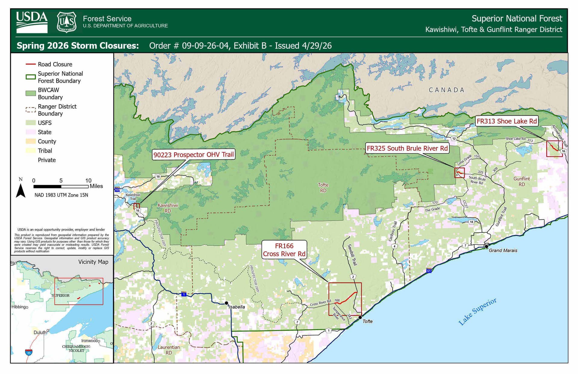
The Superior National Forest is warning that heavy rain and melting snow have caused washouts across the forest. To keep visitors safe, an emergency closure (09-09-26-04) is now in effect for three ranger districts.
- Effective: Now
- Where: Check the latest list and map on the Alerts page.
Areas will reopen as soon as they are repaired. Please check the forest’s website or social media before you travel.
Forest Roads
The following forest roads have washouts which make them not drivable. They are currently closed due to unsafe conditions.
Gunflint Ranger District (Northeast side of the forest, Grand Marias)
- Forest Road 313-Shoe Lake Road, from the intersection of the Arrowhead Trail (Cook County 16) west to Loft Lake carry-down access.
- Forest Road 325-South Brule River Road at Fiddle Creek, from the junction of Forest Road 152-Lima Grade to FR325D Spur.
- An alternative route to recreation sites – East and West Twin Lakes, Bower Trout (BWCAW entry point 43) and Ram Lake (BWCAW entry point 44) is Forest Road 152-Lima Mountain Road, approximately 4 miles north of the FR325-South Brule River Road intersection on the Gunflint Trail (Cook County 12).
Kawishiwi Ranger District (Northern portion of the forest, Ely area)
- South Farm Lake culvert washout, on Kawishiwi Trail/Prospector ATV/OHV Trail, road closure is near end of Lake County Road 16 to Gate No. 3 of Prospector ATV Trail.
Tofte Ranger District (Southeast side of the forest)
- Forest Road 166-Cross River Road, closed at the junction of the Temperance River Road (approximately 5.15 miles northwest of State Highway 61) going east (approximately 4.9 miles) to County Road 2.
Recreation Sites and Campgrounds
All developed and dispersed recreation sites including developed campgrounds on the forest are still planned to open for visitor use this next weekend. As road and water conditions change, recreation sites will be reevaluated. Be cautious of lake levels and boat access dock areas.
Wilderness Entry Points
There are currently no known washouts or flooded roads to Boundary Waters Canoe Area Wilderness (BWCAW) Entry Points; they all remain accessible.

John is the Interim News Director for Civic Media. Reach him at john.scott@civicmedia.us.
Want More Local News?
Civic Media
Civic Media Inc.
The Civic Media App
Put us in your pocket.
