
Aug 22, 2025, 10:51 AM CT
Share
WAUSAU, Wis. (CIVIC MEDIA) – A break from the heat and humidity is coming as a different airmass shifts into the state, dragging in rain, cooler temperatures and feisty winds.
Will it be temporary sweater weather? For some. Flannels will likely be in full force. As crisp air paired with gusty winds moves in over the weekend, it’ll feel rather chilly for late August. It can be considered football weather – perfect timing.

A cold front marches through Wisconsin on Friday, Aug 22. Skies will become cloudy statewide by the afternoon and chances for showers and some thunderstorms sweep across the northern half of the state.
Areas far north may receive a quick 1.0″ or more of rainfall. There could also be high winds and hail. The Storm Prediction Center has put the Northwoods in a marginal risk (1 out of 5) for a strong storm.
Rain amounts look light for the rest of the state as the front passes by, bringing just a trace of rain and spotty sprinkles overnight into Saturday, Aug 23.
As winds crank out of the northwest, it’ll be blustery, and it could spark spotty, scattered sprinkles statewide Saturday.
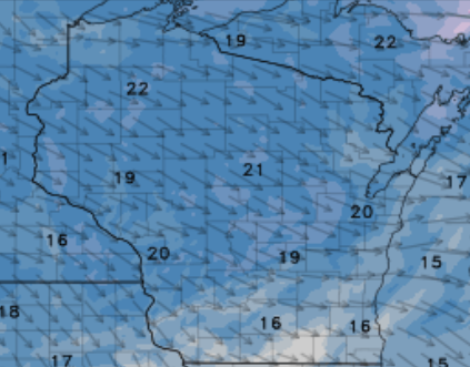
Multiple days of below average high temperatures settle in; get cozy, because it’ll stick around from Saturday through Tuesday, Aug 26. The weather will be dealing us daily highs 10-30 degrees below normal. Temperatures Sunday, Aug 24 far northeast may only hit highs in the upper 40s, while mid 60s are likely further south.
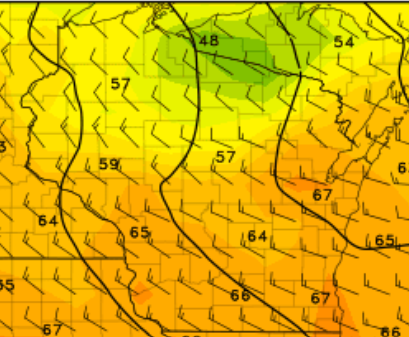
Good news: things warm back up by middle of next week. Which means for Labor Day Weekend, summer weather returns. Highs are currently forecasted to be in the 70s to near 80 degrees for the holiday stretch.

Brittney Merlot is Civic Media’s Meteorologist. Email her at brittney.merlot@civicmedia.us.
Want More Local News?
Civic Media
Civic Media Inc.
The Civic Media App
Put us in your pocket.
