Severe weather threat returns for Wisconsin in winter
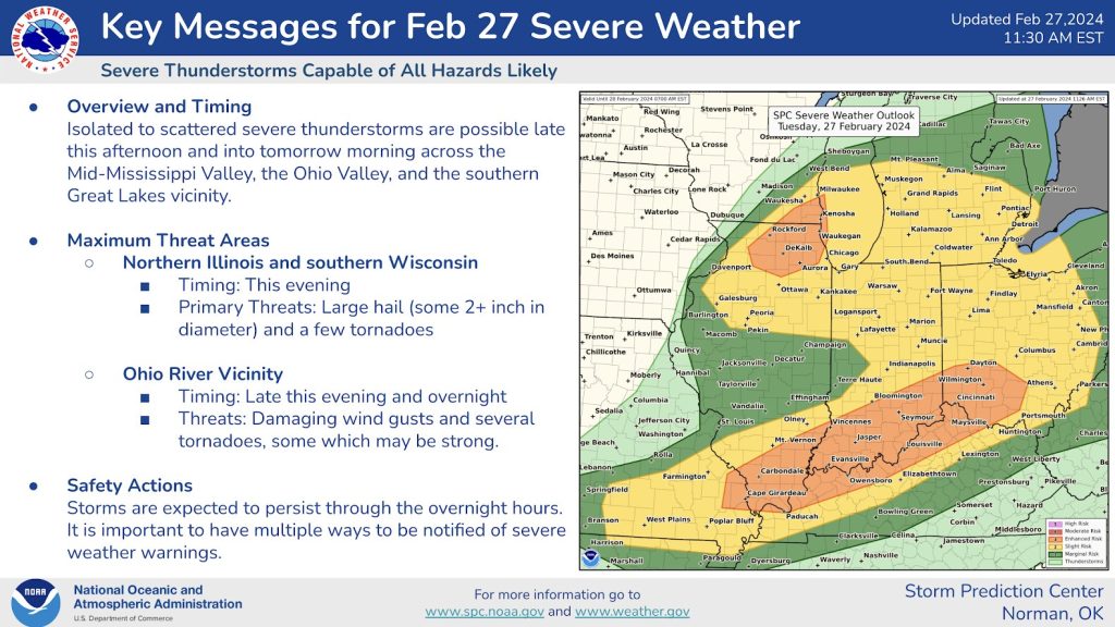
MILWAUKEE, Wis. (CIVIC MEDIA) – Tornadoes are possible as the Storm Prediction Center upgrades to an ‘Enhanced Risk’ for severe storms. Including large hail and some tornadoes.
We know that tornadoes are possible in February, after Evansville was hit with an EF-2 just 19 days ago. That marked the first tornado ever, in the month of February throughout the state.
Now the threat returns.

Kenosha, Racine and Walworth counties are in the bullseye. With Rock, Waukesha and Milwaukee counties along the possible path too.
The National Weather Service says scattered strong to severe thunderstorms will fire up in north western Illinois late this afternoon. Storms will then travel northeast and may pack a punch when they arrive here in Wisconsin.
With sunny skies and highs striking the 70s, shattering daily record highs… it’s building the atmosphere up for storms.
But behind the Spring-like temps, cold weather strikes. Dragging in a 45 degree temperature swing. Highs in Milwaukee today are scraping 70 and tomorrow they will barely feel like the mid 20’s. This big change in temperature so rapidly, fires up chances for vicious thunderstorms.
The main threat for Wisconsin will be large hail, with some the size of eggs. This kind of storm would damage roofs and break windshields.
Tornadoes are also possible.
Winds may also gust and do damage, with widespread power outages.
Take the time now to be sure your WEA emergency alert system on your cell phone is flipped on. Have a shelter and plan in place and practice it. Because panic sets in when emergencies strike.
- Be Weather-Ready: Check the forecast regularly to see if you’re at risk for tornadoes. Listen to local news or a NOAA Weather Radio to stay informed about tornado watches and warnings. Check the Weather-Ready Nation for tips.
- Sign Up for Notifications: Know how your community sends warnings. Some communities have outdoor sirens. Others depend on media and smart phones to alert residents of severe storms capable of producing tornadoes.
- Create a Communications Plan: Have a family plan that includes an emergency meeting place and related information. If you live in a mobile home or home without a basement, identify a nearby safe building you can get too quickly, such as a church or family member.
- Pick a safe room in your home, such as a basement, storm cellar, or an interior room on the lowest floor with no windows. Check more ideas for your family plan at: https://www.ready.gov/make-a-plan
- Practice Your Plan: Conduct a family severe thunderstorm drill regularly so everyone knows what to do if a tornado is approaching. Make sure all members of your family know to go there when tornado warnings are issued. Don’t forget pets if time allows.
- Prepare Your Home: Consider having your safe room reinforced. You can find plans for reinforcing an interior room to provide better protection on the Federal Emergency Management Agency website.
- Help Your Neighbor: Encourage your loved ones to prepare for the possibility of tornadoes. Take CPR training so you can help if someone is hurt.
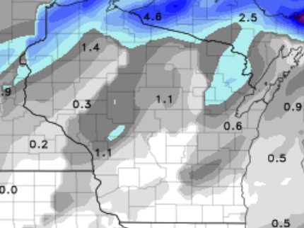
Wildest part, afterwards some snow is still expected to coat most of the state. Bringing under an inch for most. However, Iron county in the northern part of the state, is under a Winter Weather Advisory. As the cold air returns and blasts over Lake Superior, chances of 2-5″ of snow will pile up.


Brittney Merlot is Civic Media’s Meteorologist. Email her at [email protected].
Want More Local News?
Civic Media
Civic Media Inc.
The Civic Media App
Put us in your pocket.
